> Development > Disaster Management


The Hindu Kush Himalaya (HKH) region, often called the Third Pole for holding the largest reserve of frozen freshwater outside the polar ice sheets, is undergoing glacier loss at a pace that recent scientific assessments describe as unprecedented within the observational record. Stretching roughly 3,500 kilometres across eight countries, from Afghanistan in the west to Myanmar in the east, the HKH feeds ten major Asian river systems, including the Indus, Ganga and Brahmaputra, and underpins the water, food and energy security of nearly two billion people living downstream. New research released to mark World Day for Glaciers in March 2026 confirms what mountain communities and scientists have long observed on the ground, as they are regarded as the cryosphere of the HKH is retreating faster, and the consequences are becoming harder to reverse.
Two landmark reports published by the International Centre for Integrated Mountain Development (ICIMOD), Changing Dynamics of Glaciers in the Hindu Kush Himalaya Region from 1990 to 2020 and HKH Glacier Outlook 2026: Insights from 50 Years of Himalayan Glacier Monitoring. They draw on five decades of field observation, including 302 annual measurements from 38 representative glaciers monitored since 1974. Their central finding is stark in nature that the rate of ice wastage across the region has roughly doubled since the year 2000. According to ICIMOD, across the full observational period, glaciers recorded a negative mass balance in about 89 percent of years, a level of consistency that leaves little ambiguity about the direction of change. The organisation also documented that since 1975, glaciers in the region have lost up to 27 metres of ice thickness, a scale of thinning that some scientists now describe as approaching tipping points beyond which retreat may become effectively irreversible (ICIMOD, 2026a).
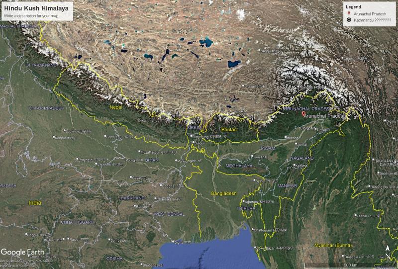 Image : Google Earth Pro satellite imagery (Landsat/Copernicus), with data from SIO, NOAA, U.S. Navy, NGA, and GEBCO.
The 1990 to 2020 mapping exercise catalogued 63,761 glaciers across the HKH, covering nearly 55,782 square kilometres, but loss has not been uniform across river basins. The Indus basin, which holds the largest share of glaciers in the region, lost about 6 percent of its glacierised area over the three decades studied, while the Ganga and Brahmaputra basins recorded steeper reductions of 21 percent and 16 percent respectively, despite hosting some of the region's largest ice bodies. Data shows that smaller glaciers, those below 0.5 square kilometres in area, are shrinking fastest of all, and they make up roughly three quarters of all glaciers in the region, meaning localised water shortages are likely to intensify well before the largest glaciers show comparable decline. Therefore, the question emerged why melt of glaciers is accelerating?
The physical drivers of this acceleration are increasingly well understood. Around 78 percent of glacierised area in the HKH lies between 4,500 and 6,000 metres above sea level, a zone that is disproportionately exposed to elevation dependent warming, whereby high altitude environments warm faster than the global average. Earlier assessments, including ICIMOD's 2023 HI-WISE report led by Philippus Wester, had already found that HKH glaciers lost ice 65 percent faster during the 2011 to 2020 decade compared with the decade before, a trend the 2026 findings show has continued and, in places, deepened. Compounding rising temperatures, changes in the South Asian monsoon, shifting snowfall patterns and the deposition of black carbon and dust on ice surfaces, which reduces reflectivity and speeds absorption of solar heat, are together reshaping the region's cryosphere faster than earlier climate models anticipated.
Projections tied to global emissions trajectories illustrate how much is still at stake. Even under the most ambitious Paris Agreement target of limiting warming to 1.5 degrees Celsius, HKH glaciers are expected to lose between 30 and 50 percent of their volume by 2100 (ICIMOD, 2023). Under a 3 degree warming pathway, closer to the trajectory implied by current global climate policy, the Eastern Himalaya, spanning Nepal and Bhutan, could lose up to 75 percent of its ice, rising to 80 percent at 4 degrees of warming (Malay Mail, 2023). The difference between these scenarios is not an abstraction for policy debate; it is the difference between a manageable transition for mountain and downstream communities and a hydrological transformation that outpaces most existing adaptation planning. But can we ignore the consequences of water, hazards, and livelihoods insecurity?
In the near term, accelerated melt is expected to increase river flows in the Ganga, Brahmaputra and Indus basins through roughly 2050, before flows decline as glacial reserves are depleted later in the century. Rivers in the Eastern Himalaya, which depend more heavily on glacial melt relative to monsoon rainfall, are projected to see the sharpest reductions, with some perennial rivers at risk of becoming seasonal. For high mountain communities across Assam, Sikkim, Ladakh, Nepal, Bhutan and the wider basin, this trajectory threatens irrigation, drinking water supply and hydropower generation at a scale that current infrastructure and governance frameworks are not designed to absorb.
Faster melt also raises the frequency and severity of glacial lake outburst floods, or GLOFs, as meltwater accumulates behind unstable moraine dams that can fail with little warning, sending debris laden floodwaters through downstream valleys. ICIMOD's 2026 findings note that the rapid retreat of smaller glaciers in particular is intensifying such hazards alongside more localised water stress. Beyond hydrology, the HKH's four biodiversity hotspots and the ecosystems and livelihoods dependent on them are also at risk, even under relatively contained warming scenarios of 1.5 degrees Celsius.
What these projections mean on the ground became painfully visible in Nepal this monsoon. On the morning of 26 August 2026, a mass of bedrock carrying a hanging glacier broke away from the north face of the Lirung massif in the Langtang Himal at roughly 5,200 metres and fell about 1,200 metres into the Lhende Khola, a tributary of the Bhote Koshi (Unda, 2026). The collapse turned into a fast moving torrent of rock, ice and liquefied sediment that reached Gyirong Port on the Chinese side within seven minutes, then crossed into Nepal at Rasuwagadhi, destroying the border complex, the trading village of Timure and the town of Syabrubesi before surging down the Trishuli towards the Narayani (Unda, 2026). The event was so large that seismometers around the world recorded it, and it was first misreported as an earthquake (EarthSky, 2026). A month later, the Government of Nepal reports more than 1,400 deaths and over 6,000 people still missing, most of them on the Nepali side of the border and including several hundred foreign pilgrims and tourists (OnlineKhabar, 2026). Nepal's disaster management authority estimates that 1.6 million people were affected, while 41 bridges were washed away and hydropower tunnels along the valley became sites of search and recovery (Convoy of Hope, 2026). Researchers mapping the valley consider it the largest flood in the Trishuli in roughly 5,000 years (CLaSH, 2026).
The Rasuwa disaster is an alert precisely because it did not follow the script that hazard planning had prepared for. Nepal was not unprepared; it maintained glacial lake inventories, satellite monitoring, early warning systems and international scientific partnerships, yet almost all of this effort was directed at glacial lakes, while the disaster began on a rock face that no inventory had catalogued (Unda, 2026). Glaciologists have emphasised that the event was not a GLOF but a cascade of hazards, in which the failure of ice and bedrock produced avalanches, debris flows, temporary and unstable river dams, and finally catastrophic flooding (AntarcticGlaciers.org, 2026). Even the warning infrastructure was overtaken. Travelling at more than 160 kilometres an hour, the flood reached Timure in about 16 minutes and destroyed the upstream Rasuwagadhi stream gauge before it could send an emergency alert (CLaSH, 2026). Days afterwards, a new lake pooled behind the debris and burst, sending a second surge through the same valley (The Conversation, 2026). Scientists have said that climate change likely helped trigger the collapse, as warming weakens the ice and thaws the permafrost that hold steep Himalayan slopes together (EarthSky, 2026).
Nor was this an isolated shock. In July 2025, a flood on the same Lhende and Bhote Koshi rivers, linked to monsoon rain and a likely glacial lake outburst, swept away the Nepal China Friendship Bridge at Rasuwagadhi, killed at least nine people and damaged hydropower installations (News On Air, 2025), and in August 2024 two glacial lakes burst above Thame village in the Everest region. The same corridor has thus faced two very different glacier related disasters in little more than a year. For Northeast India the warning is direct. The 2023 South Lhonak disaster in Sikkim began when thawing permafrost sent rock crashing into a glacial lake (The Conversation, 2026), and the Eastern Himalaya that feeds the Teesta and the Brahmaputra shares the same steep, warming and heavily engineered terrain. Nepal's tragedy shows that the retreat of the Third Pole is no longer only a slow story of shrinking ice and future water stress; it is an immediate question of life and death in mountain valleys, and risk assessment that watches the lakes but not the slopes above them will keep being taken by surprise.
The United Nations designated 2025 as the International Year of Glaciers' Preservation and marked the beginning of the Decade of Action for Cryospheric Sciences, running from 2025 to 2034. Yet ICIMOD's authors caution that glacier monitoring across the HKH remains thin and unevenly distributed, with only a small fraction of the region's tens of thousands of glaciers under sustained observation. Their reports call for a substantial scale up in monitoring infrastructure, greater standardisation of measurement methodology across the eight HKH countries, and sustained investment in climate resilient adaptation planning for the communities most exposed to changing water availability.
For a region that is home to roughly 240 million mountain residents and supplies water to nearly two billion people downstream, the accelerating loss of Himalayan ice is not a distant environmental concern but an unfolding hydrological and social crisis. The evidence assembled from the Nepal flash floods exposed that without a marked change in global emissions trajectories and a parallel investment in regional monitoring and adaptation, the retreat of the Third Pole's glaciers will continue to outpace the capacity of downstream communities and governments to adjust.
 Navigations
  Quick Contact
 Subscribe Us
 Quick Mail