> Science > Conservation
Looking Beyond Embankments
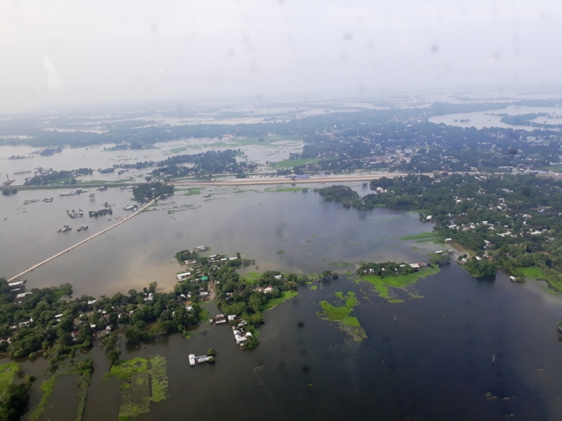
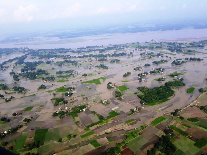
Showing customary disquiet over the breaches of outlasted embankments in yet another wave of perennial flood should not disguise the unreasonableness of such traditional deterrent techniques. Of late, the outcome of dipping a river basin level problem into just an entry by “Drainage and Embankments” in List – II (State List) of the constitution has become broadly noticeable. The claims of protecting 16.49 Lakh Hectares out of 31.50 Lakh Hectares (about 52%) flood prone area in Assam have become nightmares to millions. As per entry 56 of List I (Union List) of the constitution, the regulation and development of inter-State rivers and river valleys rest on the central government. Indeed, Brahmaputra is an international river with its drainage area of 580,000 square kilometers covering about 50.5% in China, 33.6% in India, 8.1% in Bangladesh and 7.8% in Bhutan. Even within India, the Brahmaputra basin lies in the states of Arunachal Pradesh (41.9%), Assam (36.3%), Meghalaya (6.1%), Nagaland (5.6%) and Sikkim (3.8%).
The Genesis of Flood Control
Embankments existed along the Huang He River in China even in 603 BC. There had been many incidents of breaches in the Huang He River, the most notable ones the death of millions in 1897 and devastating flood in 1931. Again, in USA, embankments were first elevated along the Mississippi River in 1777. Due to a gradual rise in flood heights, the height of embankments had to be raised up to 17 feet till 1927. In that year, the breach caused death of 350 people and extensive damages estimated in billions of dollars. In India, embankments along the banks of Damodar River in West Bengal were constructed by local Zamindars. Their maintenance was taken over by the British Government in 1846. There had been records of several water hazards due to embankment breaches. Based on such historical learning, it was stated in the Modern India Series issued by the Publications Division, Ministry of Information & Broadcasting in 1949, "The present policy of keeping floods in check by marginal embankments is not successful. It costs large sums of money, is un-remunerative, and does not provide protection against major floods."
In spite of proven shortcomings of such short-term measures, the then Prime Minister Pandit Jawaharlal Nehru said at the annual meeting of the Central Board of Irrigation and Power in 1953, "When floods appear, we run with a shovel in our hands to collect earth for preventing floods." In a similar legacy, on 14th September 1954, Gulzarilal Nanda, Union Minister for Planning said, “If we can muster 230,000 able-bodied persons for a period of four months each year, the work of the construction of embankments on both sides of the Kosi can be completed within a period of two years, instead of the scheduled period of six." In the similar lines, Bishnuram Medhi, the Chief Minister of Assam said in September 1954, “We hope to take up immediately a scheme for running embankments along the Brahmaputra, from a point near the foot-hills to the point where it reaches the border of the State."
With this inheritance, the national flood management policy has evolved through various stages of comprehensive understanding of the problem. As per the policy statement in the Parliament in 1954, the objective was to rid the nation from the menace of floods by containing and managing floods, which was later modified as reasonable protection to the extent of technically and economically justifiable. However, within two years of above policy announcement in 1956, the Union Minister of Irrigation and Power said in the Parliament that absolute immunity from flood damage is not physically possible because of unpredictable natural forces and adaptability to an extent is imminent.
As per the first five year plan, “The construction of large dams to store these flood waters is the most effective way of preventing flood damage”. However, National Commission on Floods (NCF) observed that the construction of the reservoirs in the Himalayan region has to deal with geological, seismic and topographical constraints. The lower economic life of the reservoirs because of narrow valleys, low capacities of reservoirs and large silt charge affects the economic feasibility of the project.
The High Level Committee by the Union Government, in its report in December 1957 emphasized that priority should be given to soil conservation and watershed development and that comprehensive appraisal of the embankment schemes should be taken up before their inclusion in the plans. The Ministers Committee on Flood Control in 1964 emphasized on the non-physical measures like flood warning, forecasting, flood plain zoning and flood insurance. Another Ministers’ Committee on floods and flood relief in 1972 recommended that each flood affected state should frame programs of soil conservation. Even if a model draft bill for Flood Plain Zoning was circulated in 1975, Manipur was the only state that enacted legislation on the suggested lines. The Working Group on Flood Control in its report in 1978 emphasized on the critical examination of all major existing works and evaluation of the long term effects of embankments on river regimes. The comprehensive report by the National Commission on Floods under the Chairmanship of Jaysukhlal Hathi in 1980 reviewed the flood protection measures undertaken since 1954 with special reference to construction of embankments in view of evolving a comprehensive approach to the flood problem.
Following an exposition by the Central Flood Control Board (CFCB) in November 1977 that the irrigation, flood control and drainage aspects could not be dealt with in isolation, four flood control commissions including the Brahmaputra Flood Control Commission were set up to prepare integrated flood management plans of the river basins. The Central Water Commission assessed the performance of the embankments in 1978 and opined that unless a scientific evaluation of their performance is made on the basis of large number of case studies, it is not possible to form definite conclusion. The Chairman of Brahmaputra Flood Control Commission also pointed out that there were large scale breaches in the embankments on Brahmaputra during all major floods in Assam. The report of the NCF categorically stated that no credible assessment of performance of the embankments over any river has been done by any state. It is clear that the embankments had failed to reduce the damages due to floods; on the contrary, the average annual damage has been increasing over the years in Brahmaputra basin.
The Brahmaputra Flood Control Commission was later dissolved and the Brahmaputra Board was constituted through an act of Parliament in 1981. Since 1982, Brahmaputra Board prepared Master Plan Part-I for main stem of river Brahmaputra and Part-II for Barak River and its tributaries except Dhaleswari. Part-III includes Master Plan on 49 tributaries of the Brahmaputra, rivers of Tripura, Majuli Island and Dhaleswari. The Board’s master plans envisage the setting up of water flow, meteorological and earthquake recording stations, modernization of flood forecasting equipment, anti-erosion schemes, control on shifting cultivation, new drainage networks and multipurpose dams. On the implementation front, under State Sector Schemes as well as Union State Plans, different flood protection and management measures have been adopted under broad classification as Structural, Non-Structural and Catchment Area Treatment. However, these Master Plans have become holy books for customary reference so as to ultimately execute various immediate measures.
As recommended by the Working Group on Flood Control Program for the 10th Plan (2002-07), “It would be desirable to consider setting up an Integrated Flood Management Commission to go into all the details and make review of the flood management program in the country”. However, such mega suggestion was deferred for consideration in the next Plan taking reference to US Engineer Mr. H. E. Weller’s report in 1964 on the erosion problem in the Brahmaputra Valley, where it is stated that even though it may be desirable to have a comprehensive scheme including reservoirs, it might not be feasible to implement the scheme on account of technical and other considerations.
Since the first half of 20th Century, floods changed in character from relatively harmless inundations to highly damaging disasters. The local or narrow functional approaches often conflict with the interests of the basin as a whole. The structures that are supposed to protect the people from flood are also those that have aggravated the damage potential of floods. The embankments are basically flood transfer mechanisms; embankments in the upstream quickly transfer the floods from a given area to the downstream areas. As observed by NCF, encroachment of large number of wetlands that serve as natural reservoirs has reduced the retention capacity of the drainage system causing flood level to rise.
Living with Flood
Is there any alternative to living with floods when the flood plains belong to the river? Even the Dublin and Rio conference for sustainable development agreed an objective to restore the rivers and their associated wetlands to a more natural form. The World Bank in a report in June 2005 also opined that the structural solutions are not likely to be the best options if adaptation and flexibility driven by knowledge is the criteria. Certainly, the river basin management should also be aligned with the traditional coping mechanisms by the riparian communities. The survival mechanisms ingrained in the livelihood and traditions of the riparian communities with time succor to cope with the immediate and long-term impacts of such hazards. The sufficient coping capacities of the riparian communities can prevent natural hazards like floods from turning into disasters. As pointed out by renowned Environmentalist Partha J. Das of Aranyak, the techno-engineering approach have neglected the ethno-discourses on flood management resulting in lopsided knowledge base skewed only towards structural interventions.
The climate change impacts the hydrological regimes of large rivers like the Brahmaputra that sustain millions of people, scores of ethnic cultures, and diverse ecosystems. The adverse extremities of intense rainfall in the monsoon season and post-monsoon drought-like situations are indicators of climate change in the region. The riverine flood intensity and sediment loads in the rivers have increased by intense rainfall and denudation of the fragile and tectonically dynamic hill slopes. As a result, the traditional adaptation practices of riparian communities attuned to normal climatic variations have become less effective. As a result, the annual cycles of hazards disparage people’s resilience and intensify the poverty spiral.
Managing Flood
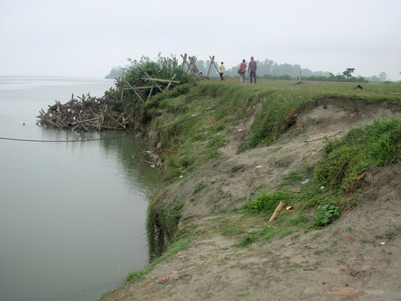
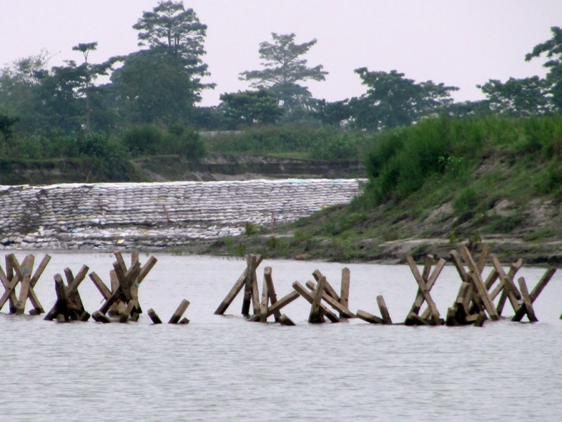
With limited hydrological data, the construction of embankments along the banks of the Brahmaputra was started in 1954. Of 15,675 kilometers of embankments constructed along various rivers in India, nearly 5,027 kilometers are on the Brahmaputra and its tributaries alone. However, such immediate remedial measures primarily for the most vulnerable reaches cannot be extended beyond 2-3 years. In reality, the extensive network of earthen embankments has deleterious impact on the regime of river and intensified the flood hazard potential of the valley. Although, these embankments helped control flood problem in the initial few years, later they have even aggravated the situation. With the construction of embankments, water remains confined and gushes out at the time of breaches and causes devastation in the area.
In 1986, Assam Flood Expert Committee observed, “The embankments have changed the behavior of rivers towards worst and therefore, no more embankments should be constructed to avoid a deterioration of the situation.” The Expert Committee also lamented that the extensive flood control measures like embankments have been undertaken without studying Brahmaputra adequately. In the words of Professor Dulal C. Goswami, “We have constructed so many embankments. Yet, engineering solutions have failed to provide any relief to the people of the Northeast. The flood situation has only aggravated in the absence of a holistic approach to tackle the situation”. Rashtriya Barh Ayog also once warned, “A stage may come when it may no longer be possible to contain the river by embankment and the present predicament proves it.” While asserting the needs of the embankments as part of short-term measures, even retired Additional Chief Engineer A. K. Mitra from Water Resources Department of Assam stressed that the government has failed to focus on medium and long term measures. The basin-level water resource management plan has to factor the anthropogenic interferences like embankments, encroachment of wetlands, massive deforestation resulting in heavy sedimentation and congestion around the riverbanks.
The Brahmaputra is one of the severely sediment-prone rivers in the world, only next to the Huang He river of China. The densely wooded hills of decades ago have astonishingly changed leaving with literally no forest left below 2000 meters. Because of denudation of forest cover, the surface runoff has considerably increased leading to devastating floods in recent years. Again, the construction of roads in the Himalayan States has also greatly endangered the stability of the Himalayan slopes and consequent large landslides are major contributors of debris and soil to the rivers. The most worried question is not only to assess the long-term impact of such human intervention on the environment but also to internalize the climate change consequences in the development plan.
Hence, the water-carrying capacity of the Brahmaputra river has gone down, causing flood during monsoon and also, undeveloped opportunity of a major waterway for transportation to the Bay of Bengal. Based on the suggestion by a number of experts, the effort to dredge the Brahmaputra was undertaken on an experimental basis in 1966. From the flood control perspective, dredging is considered to be a method for improving the discharge capacity of existing drainage system. Enhancing navigation in inland waters also requires dredging as a method for channel improvement. Here, the dredging prevented bank erosion but failed to serve as good measure because the dredged portions got immediately filled up with silts. As it a repetitive process involving huge expenditures, the dredging was not recommended for further continuation. In this context, Britain’s Environment Agency put it this way: "The concept of dredging to prevent extreme flooding is equivalent to trying to squeeze the volume of water held by a floodplain within the volume of water held in the river channel. Since the floodplain volume is usually many times larger than the channel volume, the concept becomes a major engineering project and a major environmental change." However, the Government of India has proposed a dredging programme in Brahmaputra from Sadiya to Dhubri (891 km) at an estimated project cost of about INR 40,000 crore.
The effective management of floods inculcates a long term solution with a reservoir in the upper catchment area, channelization of the rivers and tributary system, and proper watershed management in the downstream plains. The five tributaries of the Brahmaputra, namely Jiadhol, Bharali, Debang, Luhit, and Subansiri contribute about 70% of the annual yield of the Brahmaputra at Pandu. As per the mathematical modelling studies, the construction of storage reservoirs on the above tributaries will be able to moderate flood with the reduction of flood heights in the range of 0.25 to 1.75 m individually and in addition generate huge hydropower besides moderation of floods. The flood plain zoning is a key tool to regulate land use in the flood plains in order to restrict the damage due to floods, while deriving maximum benefits from the same.
The Economics of Managing Flood
The flood management plan for a river basin should be based on an integrated approach covering all relevant aspects of water management, physical planning, land use, agriculture, transport and urban development, nature conservation. In the development of a flood management plan, decision makers at all levels (local, regional, national and international) as well as stakeholders and civil society should be involved. Indeed, the way forward reposes in a multidisciplinary and transboundary approach so as to integrate the intertemporal equity in the face of climate change. For transboundary river basins, actions on international level have to be developed. The transition from flood control to water resource management even at state level can also be seen as a step in the right direction. The perennial flood in Assam is undeniably a case of suffering by the present generation with an equal concern for future generations due to continuing climate change. Leaving aside the human lives, innumerable cattle and wildlife, if we take the estimated yearly monetary figures of property loss as the prospective returns, it is a feasible investment with a discount rate moderated by the climate change and calamities, and a guaranteed return by enhancing sustainability.
Indrajit Borah
( Indrajit Borah is a freelance writer based in Delhi. He takes special interest in public policy analysis. He can be reached at [email protected]. The views expressed are the author's own )